No edit summary Tag: rte-source |
No edit summary Tag: Source edit |
||
| Line 1: | Line 1: | ||
| + | {{London_Underground_Line_Infobox|title1=Hammersmith & City Line|image1=Hammersmith & City Line Roundel.png|caption1=Official 'Hammersmith & City Line' Transport for London Roundel|image2=S7-S8 Stock Train.jpg|caption2=Hammersmith & City Line S7/S8 Rolling Stock|line_colour=Pink|no_of_stations=29|opened=10 January 1863<br>''renamed as H&C Line in 1990''|line_type=Sub-Surface|rolling_stock=S7/S8 Stock|length=25.5 km (15.8 miles)|depot(s)=Hammersmith|passenger_usage=114.6 million per year}} |
||
| − | {{Infobox TfL line|Line = Hammersmith and City|TextColour = Black|ColourName= Red|YearOpened = 1980|RollingStock = S stock|Depots = Hammersmith}} |
||
| − | }} |
||
| ⚫ | The '''Hammersmith & City line''' is a subsurface [[London Underground]] line, coloured |
||
| ⚫ | The '''Hammersmith & City line''' is a subsurface [[London Underground]] line, coloured salmon pink on the [[Tube map|London Underground Map]], connecting {{LUL stations|station=Hammersmith|line=Hammersmith & City}} in west [[London]] and {{LUL stations|station=Barking}} in east London. Formerly part of the [[Metropolitan line]], it includes the oldest underground railway in the world. The section between [[London Paddington station|Paddington]] and [[Farringdon station|Farringdon]], which opened on 10 January 1863, was the initial part of the London Underground. |
||
| ⚫ | The original Hammersmith & City line opened on 13 June 1864, although Hammersmith station itself moved to a different location in 1868. With the exception of the two-stop [[Waterloo & City line]] and the [[East London Line]] (which is now a [[London Overground]] service), it has been the least used line on the Underground. It ranks 10th of the 11 lines in passenger numbers. Out of the 29 stations served, 10 have Hammersmith & City line platforms that are wholly or almost wholly below ground, all in1 cut-and-cover, while those at Paddington, [[Edgware Road tube station|Edgware Road]], Farringdon, [[Barbican tube station|Barbican]] and [[Whitechapel station|Whitechapel]] are in |
||
| + | |||
| ⚫ | The original Hammersmith & City line opened on 13 June 1864, although Hammersmith station itself moved to a different location in 1868. With the exception of the two-stop [[Waterloo & City line]] and the [[East London Line]] (which is now a [[London Overground]] service), it has been the least used line on the Underground. It ranks 10th of the 11 lines in passenger numbers. Out of the 29 stations served, 10 have Hammersmith & City line platforms that are wholly or almost wholly below ground, all in1 cut-and-cover, while those at Paddington, [[Edgware Road tube station|Edgware Road]], Farringdon, [[Barbican tube station|Barbican]] and [[Whitechapel station|Whitechapel]] are in cuttings or under train-sheds albeit below street level. |
||
Since December 2009 the route between Hammersmith and {{LUL stations|station=Liverpool Street}} has been supplemented by the [[Circle line (London Underground)|Circle line]]. With this change, the Hammersmith & City line no longer has any stations unique to it. |
Since December 2009 the route between Hammersmith and {{LUL stations|station=Liverpool Street}} has been supplemented by the [[Circle line (London Underground)|Circle line]]. With this change, the Hammersmith & City line no longer has any stations unique to it. |
||
| Line 18: | Line 18: | ||
==Map== |
==Map== |
||
| − | [[File: |
+ | [[File:Map of H&C London Underground Line.png|alt=Geographically accurate map of the Hammersmith and City Line|center|Geographically accurate map of the Hammersmith and City Line]] |
| + | <br /> |
||
| − | Map of the line before the new Wood Lane station was added and before Shepherd's Bush (H&C) was renamed Shepherd's Bush Market. |
||
==Stations== |
==Stations== |
||
| + | <br /> |
||
| ⚫ | |||
| − | [[File:C Stock at Wood Lane.JPG|thumb|right|250px|Hammersmith & City line train at {{LUL stations|station=Wood Lane}}]] |
||
| − | {{GeoGroupTemplate}} |
||
| − | ''in order from west to east'' |
||
| − | |||
{| class="wikitable" border="2" |
{| class="wikitable" border="2" |
||
|- |
|- |
||
! Station !! Image !! Opened !! Additional information |
! Station !! Image !! Opened !! Additional information |
||
|- |
|- |
||
| − | |[[Hammersmith tube station (Hammersmith & City and Circle lines)|Hammersmith]] {{access icon}} || [[File:Hammersmith (H & C line) station building.JPG|50px]] |
+ | |[[Hammersmith tube station (Hammersmith & City and Circle lines)|Hammersmith]] {{access icon}} || [[File:Hammersmith (H & C line) station building.JPG|50px|link=Special:FilePath/Hammersmith_(H_&_C_line)_station_building.JPG]]|| 1 December 1868 || Original station opened 13 June 1864, change for [[Circle line]]{{ref|map 1|map 1}} |
|- |
|- |
||
| − | |[[Goldhawk Road tube station|Goldhawk Road]] || [[File:Goldhawk Road stn west entrance.JPG|50px]] |
+ | |[[Goldhawk Road tube station|Goldhawk Road]] || [[File:Goldhawk Road stn west entrance.JPG|50px|link=Special:FilePath/Goldhawk_Road_stn_west_entrance.JPG]]|| 1 April 1914 ||{{ref|map 2|map 2}} |
|- |
|- |
||
| − | |[[Shepherd's Bush Market]] || [[File:Shepherd's Bush Market stn east entrance.JPG|50px]] |
+ | |[[Shepherd's Bush Market]] || [[File:Shepherd's Bush Market stn east entrance.JPG|50px|link=Special:FilePath/Shepherd's_Bush_Market_stn_east_entrance.JPG]]|| 1 April 1914 || Opened as Shepherd's Bush on 13 June 1864{{ref|map 3|map 3}} |
|- |
|- |
||
| − | |[[Wood Lane tube station|Wood Lane]] {{access icon}} || [[File:Wood Lane stn entrance.JPG|50px]] |
+ | |[[Wood Lane tube station|Wood Lane]] {{access icon}} || [[File:Wood Lane stn entrance.JPG|50px|link=Special:FilePath/Wood_Lane_stn_entrance.JPG]]|| 12 October 2008 || Change for [[Central line]] at [[White City tube station|White City]] {{ref|map 4|map 4}} |
|- |
|- |
||
| − | |[[Latimer Road tube station|Latimer Road]] || [[File:Latimer Road Tube Station with Trellick Tower.jpg|50px]] |
+ | |[[Latimer Road tube station|Latimer Road]] || [[File:Latimer Road Tube Station with Trellick Tower.jpg|50px|link=Special:FilePath/Latimer_Road_Tube_Station_with_Trellick_Tower.jpg]]|| 16 December 1868 ||{{ref|map 5|map 5}} |
|- |
|- |
||
| − | |[[Ladbroke Grove tube station|Ladbroke Grove]] || [[File:Ladbroke Grove stn building.JPG|50px]] |
+ | |[[Ladbroke Grove tube station|Ladbroke Grove]] || [[File:Ladbroke Grove stn building.JPG|50px|link=Special:FilePath/Ladbroke_Grove_stn_building.JPG]]|| 13 June 1864 || Originally called Notting Hill, renamed Notting Hill & Ladbroke Grove in 1880, renamed Ladbroke Grove (North Kensington) on 1 June 1919, current name is from 1938{{ref|map 6|map 6}} |
|- |
|- |
||
| − | |[[Westbourne Park tube station|Westbourne Park]] || [[File:Westbourne Park stn building.JPG|50px]] |
+ | |[[Westbourne Park tube station|Westbourne Park]] || [[File:Westbourne Park stn building.JPG|50px|link=Special:FilePath/Westbourne_Park_stn_building.JPG]]|| 1 February 1866 ||{{ref|map 7|map 7}} |
|- |
|- |
||
| − | |[[Royal Oak tube station|Royal Oak]] || [[File:Royal Oak stn building.JPG|50px]] |
+ | |[[Royal Oak tube station|Royal Oak]] || [[File:Royal Oak stn building.JPG|50px|link=Special:FilePath/Royal_Oak_stn_building.JPG]]|| 30 October 1871 || {{ref|map 8|map 8}} |
|- |
|- |
||
| − | |[[Paddington station|Paddington]] {{Rail-interchange|gb|rail}} ({{Rail-interchange|air}} <small>Trains to [[Heathrow Airport|Heathrow]]</small>) || [[File:Paddington H&C station 03.jpg|50px]] |
+ | |[[Paddington station|Paddington]] {{Rail-interchange|gb|rail}} ({{Rail-interchange|air}} <small>Trains to [[Heathrow Airport|Heathrow]]</small>) || [[File:Paddington H&C station 03.jpg|50px|link=Special:FilePath/Paddington_H&C_station_03.jpg]]|| 1 December 1913 || {{ref|map 9|map 9}} |
|- |
|- |
||
| − | |[[Edgware Road tube station|Edgware Road]] || [[File:EdgwareRdHammersmith.jpg|50px]] |
+ | |[[Edgware Road tube station|Edgware Road]] || [[File:EdgwareRdHammersmith.jpg|50px|link=Special:FilePath/EdgwareRdHammersmith.jpg]]|| 1 October 1863 ||{{ref|map 10|map 10}} |
|- |
|- |
||
| − | |[[Baker Street tube station|Baker Street]] || [[File:BakerStEntrance.JPG|50px]] |
+ | |[[Baker Street tube station|Baker Street]] || [[File:BakerStEntrance.JPG|50px|link=Special:FilePath/BakerStEntrance.JPG]]|| 10 January 1863 ||{{ref|map 11|map 11}} |
|- |
|- |
||
| − | |[[Great Portland Street tube station|Great Portland Street]] || [[File:Great Portland St Tube Station.jpg|50px]] |
+ | |[[Great Portland Street tube station|Great Portland Street]] || [[File:Great Portland St Tube Station.jpg|50px|link=Special:FilePath/Great_Portland_St_Tube_Station.jpg]]|| 10 January 1863 || Originally Portland Road{{ref|map 12|map 12}} |
|- |
|- |
||
| − | |[[Euston Square tube station|Euston Square]] ({{Rail-interchange|gb|rail}} <small>[[Euston railway station|Euston]]</small>) || [[File:Euston Square stn look east.JPG|50px]] |
+ | |[[Euston Square tube station|Euston Square]] ({{Rail-interchange|gb|rail}} <small>[[Euston railway station|Euston]]</small>) || [[File:Euston Square stn look east.JPG|50px|link=Special:FilePath/Euston_Square_stn_look_east.JPG]]|| 1863 ||Originally Gower Street{{ref|map 13|map 13}} |
|- |
|- |
||
| − | |[[King's Cross St. Pancras tube station|King's Cross St Pancras]] {{access icon}} {{Rail-interchange|gb|rail}} ({{Rail-interchange|air}} <small>Trains to [[Gatwick Airport|Gatwick]] and [[London Luton Airport|Luton]]</small>) || [[File:KXSP 2006-05-30 07.jpg|50px]] |
+ | |[[King's Cross St. Pancras tube station|King's Cross St Pancras]] {{access icon}} {{Rail-interchange|gb|rail}} ({{Rail-interchange|air}} <small>Trains to [[Gatwick Airport|Gatwick]] and [[London Luton Airport|Luton]]</small>) || [[File:KXSP 2006-05-30 07.jpg|50px|link=Special:FilePath/KXSP_2006-05-30_07.jpg]]|| 1863 ||{{ref|map 14|map 14}} |
|- |
|- |
||
| − | |[[Farringdon station|Farringdon]] {{Rail-interchange|gb|rail}} ({{Rail-interchange|air}} <small>Trains to [[Gatwick Airport|Gatwick]] and [[London Luton Airport|Luton]]</small>) || [[File:Farringdon station exterior.jpg|50px]] |
+ | |[[Farringdon station|Farringdon]] {{Rail-interchange|gb|rail}} ({{Rail-interchange|air}} <small>Trains to [[Gatwick Airport|Gatwick]] and [[London Luton Airport|Luton]]</small>) || [[File:Farringdon station exterior.jpg|50px|link=Special:FilePath/Farringdon_station_exterior.jpg]]|| 10 January 1863 ||{{ref|map 15|map 15}} |
|- |
|- |
||
| − | |[[Barbican tube station|Barbican]] || [[File:Barbican station entrance.JPG|50px]] |
+ | |[[Barbican tube station|Barbican]] || [[File:Barbican station entrance.JPG|50px|link=Special:FilePath/Barbican_station_entrance.JPG]]|| 1865 || Opened as Aldersgate Street, renamed to Aldersgate in 1910, renamed Aldersgate and Barbican in 1923, current name is from 1968{{ref|map 16|map 16}} |
|- |
|- |
||
| − | |[[Moorgate station|Moorgate]] {{Rail-interchange|gb|rail}} || [[File:Moorgate.jpg|50px]] |
+ | |[[Moorgate station|Moorgate]] {{Rail-interchange|gb|rail}} || [[File:Moorgate.jpg|50px|link=Special:FilePath/Moorgate.jpg]]|| 1865 ||{{ref|map 17|map 17}} |
|- |
|- |
||
| − | |[[Liverpool Street station|Liverpool Street]] {{Rail-interchange|gb|rail}} ({{Rail-interchange|air}} <small>Trains to [[London Stansted Airport|Stansted]]</small>) || [[File:Liverpool Street Underground concourse entr.JPG|50px]] |
+ | |[[Liverpool Street station|Liverpool Street]] {{Rail-interchange|gb|rail}} ({{Rail-interchange|air}} <small>Trains to [[London Stansted Airport|Stansted]]</small>) || [[File:Liverpool Street Underground concourse entr.JPG|50px|link=Special:FilePath/Liverpool_Street_Underground_concourse_entr.JPG]]|| 12 July 1875 || Opened as Bishopsgate, renamed 1 November 1909{{ref|map 18|map 18}} |
|- |
|- |
||
| − | |[[Aldgate East tube station|Aldgate East]] || [[File:Aldgate East stn southwest entrance.JPG|50px]] |
+ | |[[Aldgate East tube station|Aldgate East]] || [[File:Aldgate East stn southwest entrance.JPG|50px|link=Special:FilePath/Aldgate_East_stn_southwest_entrance.JPG]]|| 6 October 1884 ||{{ref|map 19|map 19}} |
|- |
|- |
||
| − | |[[Whitechapel station|Whitechapel]] || [[File:Whitechapel tube station entrance.jpg|50px]] |
+ | |[[Whitechapel station|Whitechapel]] || [[File:Whitechapel tube station entrance.jpg|50px|link=Special:FilePath/Whitechapel_tube_station_entrance.jpg]]|| 6 October 1884 ||{{ref|map 20|map 20}} |
|- |
|- |
||
| − | |[[Stepney Green tube station|Stepney Green]] || [[File:Stepney Green stn building.JPG|50px]] |
+ | |[[Stepney Green tube station|Stepney Green]] || [[File:Stepney Green stn building.JPG|50px|link=Special:FilePath/Stepney_Green_stn_building.JPG]]|| 1902 ||{{ref|map 21|map 21}} |
|- |
|- |
||
| − | |[[Mile End tube station|Mile End]] || [[File:Mile End stn entrance.JPG|50px]] |
+ | |[[Mile End tube station|Mile End]] || [[File:Mile End stn entrance.JPG|50px|link=Special:FilePath/Mile_End_stn_entrance.JPG]]|| 1902 ||{{ref|map 22|map 22}} |
|- |
|- |
||
| − | |[[Bow Road tube station|Bow Road]] || [[File:Bow Road stn building.JPG|50px]] |
+ | |[[Bow Road tube station|Bow Road]] || [[File:Bow Road stn building.JPG|50px|link=Special:FilePath/Bow_Road_stn_building.JPG]]|| 1902 ||{{ref|map 23|map 23}} |
|- |
|- |
||
| − | |[[Bromley-by-Bow tube station|Bromley-by-Bow]] || [[File:Bromley-by-Bow stn entrance.JPG|50px]] |
+ | |[[Bromley-by-Bow tube station|Bromley-by-Bow]] || [[File:Bromley-by-Bow stn entrance.JPG|50px|link=Special:FilePath/Bromley-by-Bow_stn_entrance.JPG]]|| 1858 || Service for the Hammersmith and City line began in 1936{{ref|map 24|map 24}} |
|- |
|- |
||
| − | |[[West Ham station|West Ham]] {{access icon}} {{Rail-interchange|gb|rail}} || [[File:West Ham stn entrance.JPG|50px]] |
+ | |[[West Ham station|West Ham]] {{access icon}} {{Rail-interchange|gb|rail}} || [[File:West Ham stn entrance.JPG|50px|link=Special:FilePath/West_Ham_stn_entrance.JPG]]|| 1 February 1901 || New centre siding to be constructed for Hammersmith and City line trains{{ref|map 25|map 25}} |
|- |
|- |
||
| − | |[[Plaistow tube station|Plaistow]] || [[File:Plaistow station building.JPG|50px]] |
+ | |[[Plaistow tube station|Plaistow]] || [[File:Plaistow station building.JPG|50px|link=Special:FilePath/Plaistow_station_building.JPG]]|| 1858 || Service for the Hammersmith and City line began in 1936{{ref|map 26|map 26}} |
|- |
|- |
||
| − | |[[Upton Park tube station|Upton Park]] || [[File:Upton Park tube station 1.jpg|50px]] |
+ | |[[Upton Park tube station|Upton Park]] || [[File:Upton Park tube station 1.jpg|50px|link=Special:FilePath/Upton_Park_tube_station_1.jpg]]||1877 || Service for the Hammersmith and City line began in 1936{{ref|map 27|map 27}} |
|- |
|- |
||
| − | |[[East Ham tube station|East Ham]] {{access icon}} || [[File:East ham tube station london.jpg|50px]] |
+ | |[[East Ham tube station|East Ham]] {{access icon}} || [[File:East ham tube station london.jpg|50px|link=Special:FilePath/East_ham_tube_station_london.jpg]]||1858 || Service for the Hammersmith and City line began in 1988{{ref|map 28|map 28}} |
|- |
|- |
||
| − | |[[Barking station|Barking]] {{Rail-interchange|gb|rail}} {{access icon}} || [[File:Barking station 1.jpg|50px]] |
+ | |[[Barking station|Barking]] {{Rail-interchange|gb|rail}} {{access icon}} || [[File:Barking station 1.jpg|50px|link=Special:FilePath/Barking_station_1.jpg]]|| 1854 || Service for the Hammersmith and City line began in 1936{{ref|map 29|map 29}} |
|} |
|} |
||
| − | |||
| − | ==Changes in December 2009== |
||
| − | Between Hammersmith and Edgware Road, the service has been supplemented by Circle line trains since 13 December 2009, when that route changed from its previous orbital route. This is intended to cause fewer delays since, under the previous Circle line arrangements, one delayed train would affect all following trains. Having a terminus at Edgware Road, rather than the continuous orbital route, will avoid this. |
||
| − | |||
| − | The Hammersmith & City line continues to run as a separate route, with trains running to Barking and Plaistow in the east. The [[headway]] on the Hammersmith - Edgware Road leg has been reduced from seven to four minutes by this schedule change,<ref>{{cite web|url=http://www.lbhf.gov.uk/Directory/News/All_change_for_Circle_line_in_Tube_victory.asp|title=Circle line victory|publisher=London Borough of Hammersmith & Fulham|accessdate=2009-05-20}}</ref> and the alternation of Hammersmith & City with Circle trains will now provide 12 trains per hour at peak times on this section, doubling the previous frequency. |
||
==Depots== |
==Depots== |
||
| − | There is one depot, Hammersmith,{{ref|map 30|map 30}} which is located close to the Hammersmith station. However, that depot can only do minor work and other work may be done at the |
+ | There is one depot, Hammersmith,{{ref|map 30|map 30}} which is located close to the Hammersmith station. However, that depot can only do minor work and other work may be done at the Neasden Depot.<ref name="Tfl Key Facts">{{cite web |url=http://www.tfl.gov.uk/corporate/modesoftransport/londonunderground/1608.aspx |title=London Underground Key Facts |publisher=Transport for London|accessdate=2008-05-21 }}</ref>{{ref|map 31|map 31}} |
| − | == |
+ | ===References== |
| − | <div class="references-small"> |
||
| − | {{col-begin}} |
||
| − | {{Col-2}} |
||
| − | *{{note|map 1|map 1}}Hammersmith - {{Coord|51|29|39|N|000|13|30|W|region:GB_type:railwaystation|name=01 - Hammersmith tube station}} |
||
| − | *{{note|map 2|map 2}}Goldhawk Road - {{Coord|51|30|07|N|000|13|37|W|region:GB_type:railwaystation|name=02 - Goldhawk Road tube station}} |
||
| − | *{{note|map 3|map 3}}Shepherd's Bush Market - {{Coord|51|30|21|N|000|13|35|W|region:GB_type:railwaystation|name=03 - Shepherd's Bush Market tube station}} |
||
| − | *{{note|map 4|map 4}}Wood Lane - {{Coord|51|30|35|N|000|13|27|W|region:GB_type:railwaystation|name=04 - Wood Lane tube station}} |
||
| − | *{{note|map 5|map 5}}Latimer Road - {{Coord|51|30|50|N|000|13|02|W|region:GB_type:railwaystation|name=05 - Latimer Road tube station}} |
||
| − | *{{note|map 6|map 6}}Ladbroke Grove - {{Coord|51|31|02|N|000|12|38|W|region:GB_type:railwaystation|name=06 - Ladbroke Grove tube station}} |
||
| − | *{{note|map 7|map 7}}Westbourne Park - {{Coord|51|31|16|N|000|12|04|W|region:GB_type:railwaystation|name=07 - Westbourne Park tube station}} |
||
| − | *{{note|map 8|map 8}}Royal Oak - {{Coord|51|31|09|N|000|11|17|W|region:GB_type:railwaystation|name=08 - Royal Oak tube station}} |
||
| − | *{{note|map 9|map 9}}London Paddington - {{Coord|51|31|02|N|000|10|39|W|region:GB_type:railwaystation|name=09 - London Paddington station}} |
||
| − | *{{note|map 10|map 10}}Edgware Road - {{Coord|51|31|12|N|000|10|04|W|region:GB_type:railwaystation|name=10 - Edgware Road tube station}} |
||
| − | *{{note|map 11|map 11}}Baker Street - {{Coord|51|31|19|N|000|09|25|W|region:GB_type:railwaystation|name=11 - Baker Street tube station}} |
||
| − | *{{note|map 12|map 12}}Great Portland Street - {{Coord|51|31|26|N|000|08|38|W|region:GB_type:railwaystation|name=12 - Great Portland Street tube station}} |
||
| − | *{{note|map 13|map 13}}Euston Square - {{Coord|51|31|33|N|000|08|09|W|region:GB_type:railwaystation|name=13 - Euston Square tube station}} |
||
| − | *{{note|map 14|map 14}}King's Cross St. Pancras - {{Coord|51|31|49|N|000|07|27|W|region:GB_type:railwaystation|name=14 - King's Cross St. Pancras tube station}} |
||
| − | *{{note|map 15|map 15}}Farringdon - {{Coord|51|31|12|N|000|06|19|W|region:GB_type:railwaystation|name=15 - Farringdon station}} |
||
| − | {{Col-2}} |
||
| − | *{{note|map 16|map 16}}Barbican - {{Coord|51|31|13|N|000|05|52|W|region:GB_type:railwaystation|name=16 - Barbican tube station}} |
||
| − | *{{note|map 17|map 17}}Moorgate - {{Coord|51|31|07|N|000|05|19|W|region:GB_type:railwaystation|name=17 - Moorgate station}} |
||
| − | *{{note|map 18|map 18}}Liverpool Street - {{Coord|51|31|07|N|000|04|53|W|region:GB_type:railwaystation|name=18 - Liverpool Street station}} |
||
| − | *{{note|map 19|map 19}}Aldgate East - {{Coord|51|30|55|N|000|04|20|W|region:GB_type:railwaystation|name=19 - Aldgate East tube station}} |
||
| − | *{{note|map 20|map 20}}Whitechapel - {{Coord|51|31|08|N|000|03|40|W|region:GB_type:railwaystation|name=20 - Whitechapel station}} |
||
| − | *{{note|map 21|map 21}}Stepney Green - {{Coord|51|31|19|N|000|02|47|W|region:GB_type:railwaystation|name=21 - Stepney Green tube station}} |
||
| − | *{{note|map 22|map 22}}Mile End - {{Coord|51|31|30|N|000|01|59|W|region:GB_type:railwaystation|name=22 - Mile End tube station}} |
||
| − | *{{note|map 23|map 23}}Bow Road - {{Coord|51|31|38|N|000|01|29|W|region:GB_type:railwaystation|name=23 - Bow Road tube station}} |
||
| − | *{{note|map 24|map 24}}Bromley-by-Bow - {{Coord|51|31|26|N|000|00|41|W|region:GB_type:railwaystation|name=24 - Bromley-by-Bow tube station}} |
||
| − | *{{note|map 25|map 25}}West Ham - {{Coord|51|31|41|N|000|00|14|E|region:GB_type:railwaystation|name=25 - West Ham station}} |
||
| − | *{{note|map 26|map 26}}Plaistow - {{Coord|51|31|53|N|000|01|02|E|region:GB_type:railwaystation|name=26 - Plaistow tube station}} |
||
| − | *{{note|map 27|map 27}}Upton Park - {{Coord|51|32|06|N|000|02|04|E|region:GB_type:railwaystation|name=27 - Upton Park tube station}} |
||
| − | *{{note|map 28|map 28}}East Ham - {{Coord|51|32|20|N|000|03|06|E|region:GB_type:railwaystation|name=28 - East Ham tube station}} |
||
| − | *{{note|map 29|map 29}}Barking - {{Coord|51|32|21|N|000|04|54|E|region:GB_type:railwaystation|name=29 - Barking station}} |
||
| − | *{{note|map 30|map 30}}Hammersmith Depot - {{Coord|51|29|52|N|000|13|31|W|region:GB_type:railwaystation|name=30 - Hammersmith Depot}} |
||
| − | *{{note|map 31|map 31}}Neasden Depot - {{Coord|51|33|28|N|000|15|31|W|region:GB_type:railwaystation|name=31 - Neasden Depot}} |
||
| − | {{col-end}} |
||
| − | </div> |
||
| − | |||
| − | ==References== |
||
{{Reflist|colwidth=30em}} |
{{Reflist|colwidth=30em}} |
||
| + | |||
| + | ==See also== |
||
| ⚫ | |||
==External links== |
==External links== |
||
| − | + | *[https://tfl.gov.uk/tube/route/hammersmith-city/ TfL Hammersmith & City Line] |
|
| + | *[https://tfl.gov.uk/tube/timetable/hammersmith-city/ Hammersmith & City Line Timetable] |
||
| − | * {{cite web|url=http://www.tfl.gov.uk/tfl/corporate/modesoftransport/tube/linefacts/?line=hammersmithandcity |title=Hammersmith and City line facts|publisher=Transport for London|accessdate=2008-07-11}} |
||
| − | * {{cite web|url=http://www.davros.org/rail/culg/hammersmith.html |title=Hammersmith & City Line|date=2007-12-14|publisher=Clive's Underground Line Guides|accessdate=2008-07-11}} |
||
| − | |||
| − | {{Hammersmith & City line navbox}} |
||
| ⚫ | |||
| ⚫ | |||
{{DEFAULTSORT:Hammersmith & City Line}} |
{{DEFAULTSORT:Hammersmith & City Line}} |
||
| + | [[Category:London Underground Lines]] |
||
| − | |||
| ⚫ | |||
| − | [[ca:Hammersmith & City Line]] |
||
| − | [[cs:Hammersmith & City Line (linka metra v Londýně)]] |
||
| − | [[da:Hammersmith & City line]] |
||
| − | [[de:Hammersmith & City Line]] |
||
| − | [[es:Hammersmith & City Line]] |
||
| − | [[fr:Hammersmith & City line]] |
||
| − | [[gan:咸摩斯密史&實第線]] |
||
| − | [[hi:हैमरस्मिथ ऐंड सिटी लाइन]] |
||
| − | [[it:Hammersmith & City Line]] |
||
| − | [[ka:ჰამერსმით-ენდ-სიტის ხაზი]] |
||
| − | [[hu:Hammersmith & City line]] |
||
| − | [[nl:Hammersmith & City Line]] |
||
| − | [[ja:ハマースミス&シティー線]] |
||
| − | [[no:Hammersmith & City-linjen]] |
||
| − | [[nn:Hammersmith & City-linja]] |
||
| − | [[pl:Hammersmith & City Line]] |
||
| − | [[pt:Hammersmith & City line]] |
||
| − | [[ru:Хаммерсмит-энд-Сити]] |
||
| − | [[simple:Hammersmith & City line]] |
||
| − | [[sk:Hammersmith & City Line]] |
||
| − | [[sr:Хамерсмит и Сити линија]] |
||
| − | [[fi:Hammersmith & City Line]] |
||
| − | [[th:สายแฮมเมอร์สมิธและซิตี]] |
||
| − | [[zh:漢默史密斯及城市線]] |
||
| ⚫ | |||
| ⚫ | |||
| − | [[Category:Transport in Hammersmith and Fulham]] |
||
| − | [[Category:Transport in Islington]] |
||
| − | [[Category:Transport in Kensington and Chelsea]] |
||
| − | [[Category:Transport in Westminster]] |
||
| ⚫ | |||
| − | [[Category:Transport in Tower Hamlets]] |
||
| − | [[Category:Transport in Newham]] |
||
| − | [[Category:Transport in Barking and Dagenham]] |
||
| − | [[Category:Railway lines opened in 1864]] |
||
Revision as of 20:20, 25 February 2021
The Hammersmith & City line is a subsurface London Underground line, coloured salmon pink on the London Underground Map, connecting Hammersmith in west London and Barking in east London. Formerly part of the Metropolitan line, it includes the oldest underground railway in the world. The section between Paddington and Farringdon, which opened on 10 January 1863, was the initial part of the London Underground.
The original Hammersmith & City line opened on 13 June 1864, although Hammersmith station itself moved to a different location in 1868. With the exception of the two-stop Waterloo & City line and the East London Line (which is now a London Overground service), it has been the least used line on the Underground. It ranks 10th of the 11 lines in passenger numbers. Out of the 29 stations served, 10 have Hammersmith & City line platforms that are wholly or almost wholly below ground, all in1 cut-and-cover, while those at Paddington, Edgware Road, Farringdon, Barbican and Whitechapel are in cuttings or under train-sheds albeit below street level.
Since December 2009 the route between Hammersmith and Liverpool Street has been supplemented by the Circle line. With this change, the Hammersmith & City line no longer has any stations unique to it.
History
The current Hammersmith & City line was originally a branch of the Metropolitan line until 1988, though in later years it was usually operated as a separate line, with the sections not used by regular Metropolitan line trains (from Hammersmith to Baker Street and from Liverpool Street to Barking) not included on the main Metropolitan line maps. This is also reflected in the line's use of C Stock as opposed to the A Stock used on the 'main' Metropolitan line.
The name Hammersmith & City derives from the Hammersmith and City Railway (H&CR), the 5 km (Template:Convert/mi) section between Hammersmith (Grove Road) railway station and Westbourne Park that opened in 1864, which was built and operated jointly by the Metropolitan and Great Western Railways until 1868. Though now part of the Underground network, this section is an elevated railway, largely built on brick arches and bridges.
Because the name change of the route to the separate identity of the Hammersmith & City line is relatively recent, there are many stations with tiling or enamel maps that still show that they are served by the Metropolitan line, e.g. Bromley-by-Bow station, shared by the H&C and the District line. The Metropolitan line no longer has any interchange with the District.
Rolling stock
All Hammersmith & City line trains are in the distinctive London Underground livery of red, white and blue and are formed of C Stock. The line shares trains with the Circle and District (Wimbledon-Edgware Road branch) lines. Starting in 2011, the C Stock used on the Hammersmith & City and Circle lines will be replaced by new S Stock trains, which will also replace the District line's D Stock and the Metropolitan line's A Stock.
Map
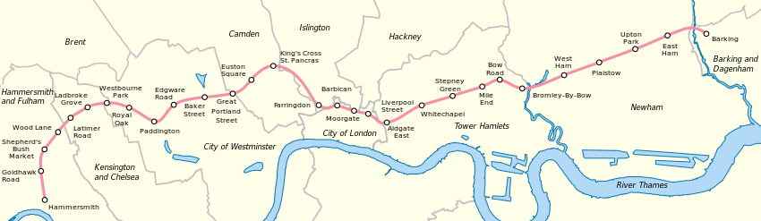
Stations
Depots
There is one depot, Hammersmith,map 30 which is located close to the Hammersmith station. However, that depot can only do minor work and other work may be done at the Neasden Depot.[1]map 31
=References
- ↑ London Underground Key Facts. Transport for London. Retrieved on 2008-05-21.
See also
External links
| |||||||||||||||||||||||||||
_station_building.JPG)